People and Geology

Geopark Heritage  People and Geology

Mining and geology have existed inseparably almost as long as the human species, making the foundation of economic, cultural, scientific, technical-technological and general social development both in the past and the present. The emergence of mining and geology is related to the man’s attempts to subordinate nature to his needs, to use resources provided by nature, make tools for work and ensure existence. It was a long road from the original collection of minerals on the earth’s surface to one of man’s greatest breakthroughs in history that occurred eight thousand years ago – that a piece of rock turns into metal when heated by fire. The old wisdom about history being the witness of time, the light and truth and the life’s teacher (testis temporum, lux veritatis and magistra vitae) confirms its truthfulness on the example of mining and geology and also teaches us that neither development nor history begins with us, that we are only a link in the ongoing process.

Rudna Glava Mine

Searching for and collecting flint, obsidian and pigment are the germs of the common beginning of mining and geology. Archaeology indicates that the roots of mining, geology and metallurgy lie in the territory of Serbia in prehistory, which is proved by numerous archaeological sites, specific representative cultural monuments from the beginnings of mining, geology and metallurgy in the Neolithic and the early Eneolithic, including Rudna Glava near Majdanpek, Belovode in the vicinity of Petrovac on the Mlava River, Pločnik near Prokuplje, Mali Šturac (Prlovi) at Rudnik, Stojnik at Kosmaj, Jarmovac near Priboj, Deli Jovan, Rujnik etc.

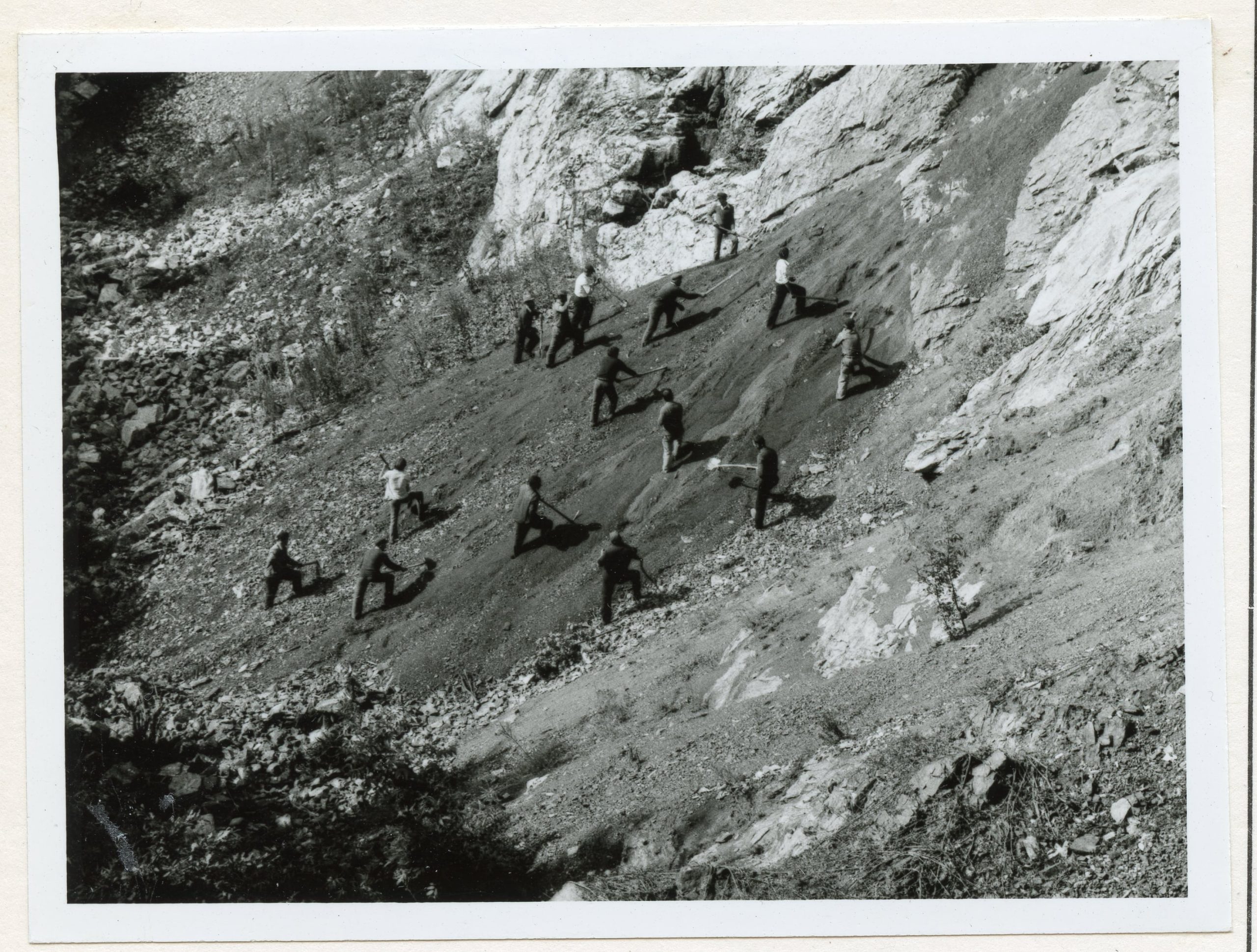
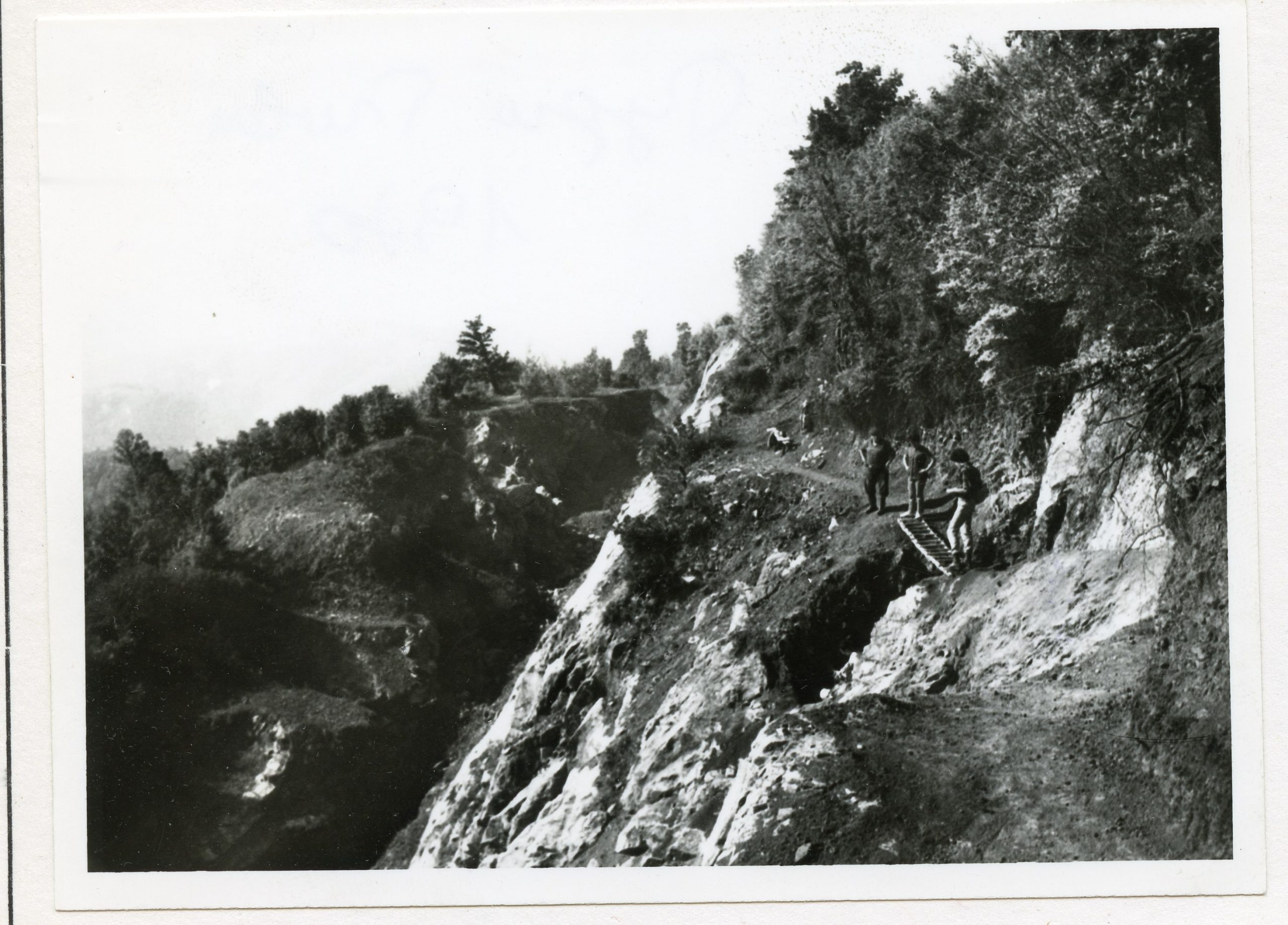
In the first half of the 20th century, during the years-long operation of the modern mine of iron ore – magnetite, on a  hill above the village of Rudna Glava, the remains of old mining works, mining shafts, were discovered, dating back to the prehistoric period, as well as the traces of mining galleries from the ancient times. In the 1960s, after stopping the exploitation of the modern mine, archaeological explorations of ancient mining began. They lasted as many as two decades and, thanks to them, today we know the locality of the “Mine – Open Pit”, as this archaeological site is called, as the oldest copper mine in Europe and one of the oldest in the world (second half of the 6th and the beginning of the 5th millennium BC – the Vinča culture). This place is considered the starting point and foundation for the future development of European culture and civilization, i.e., the place where the metal age revolution began.

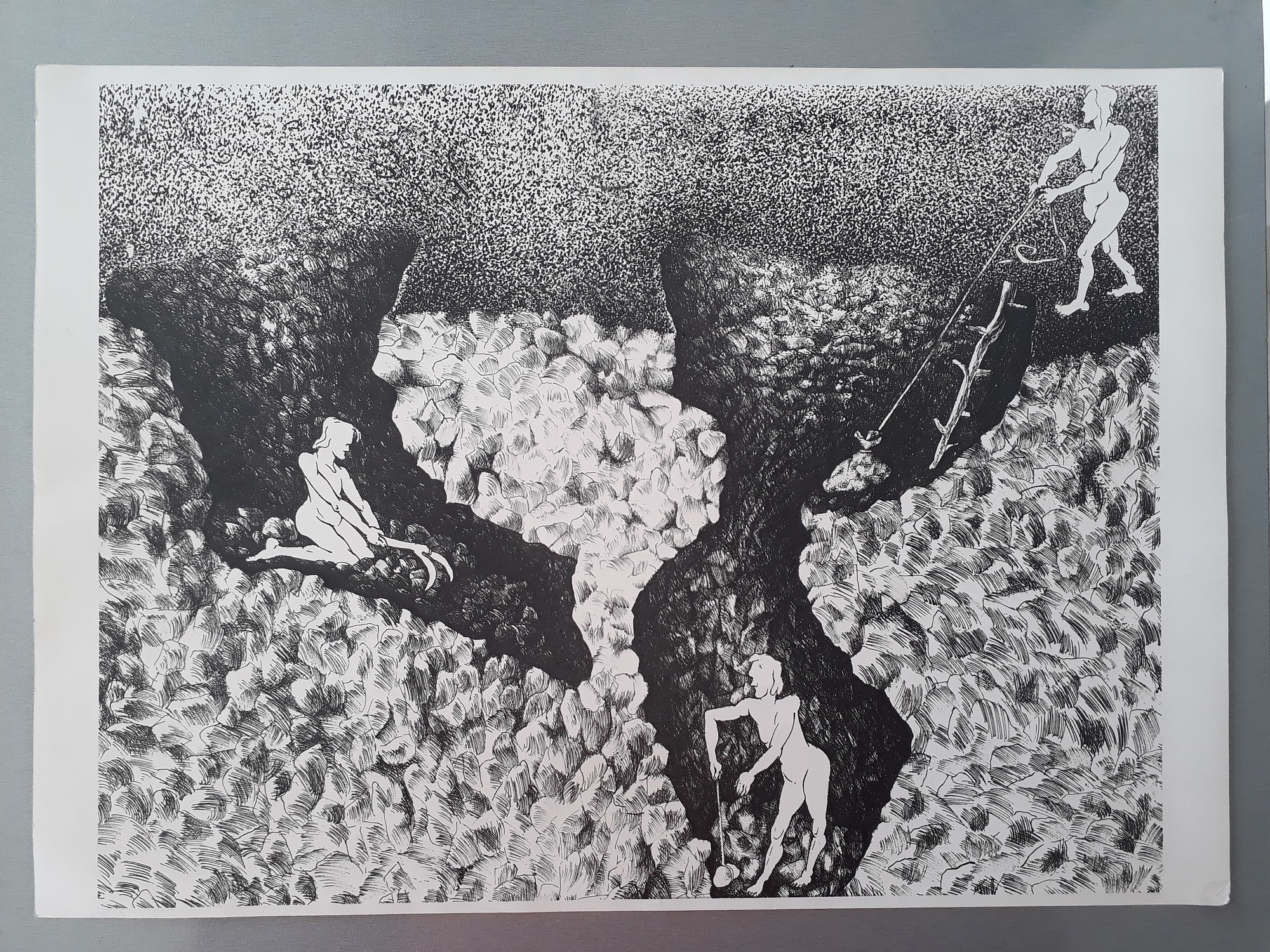
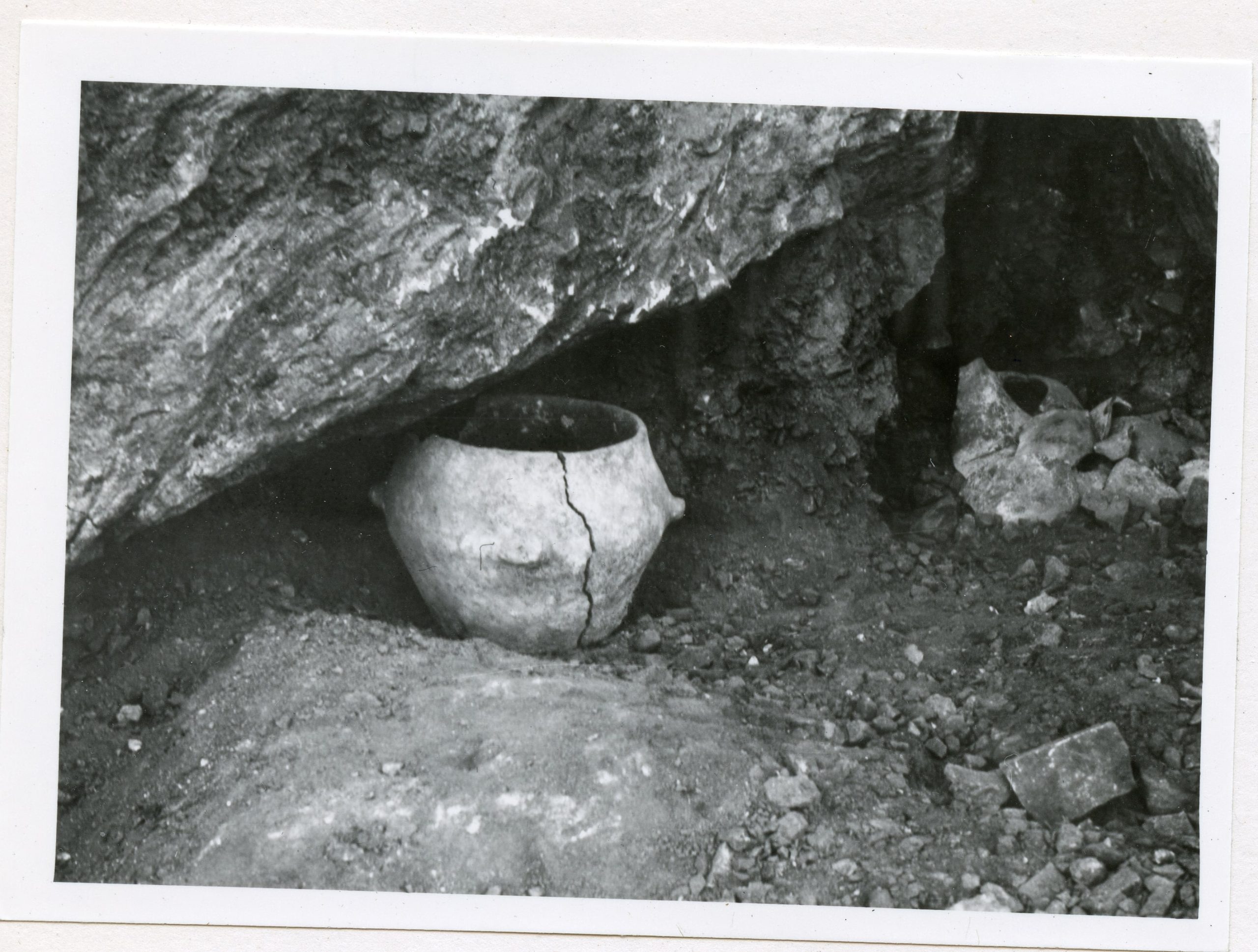
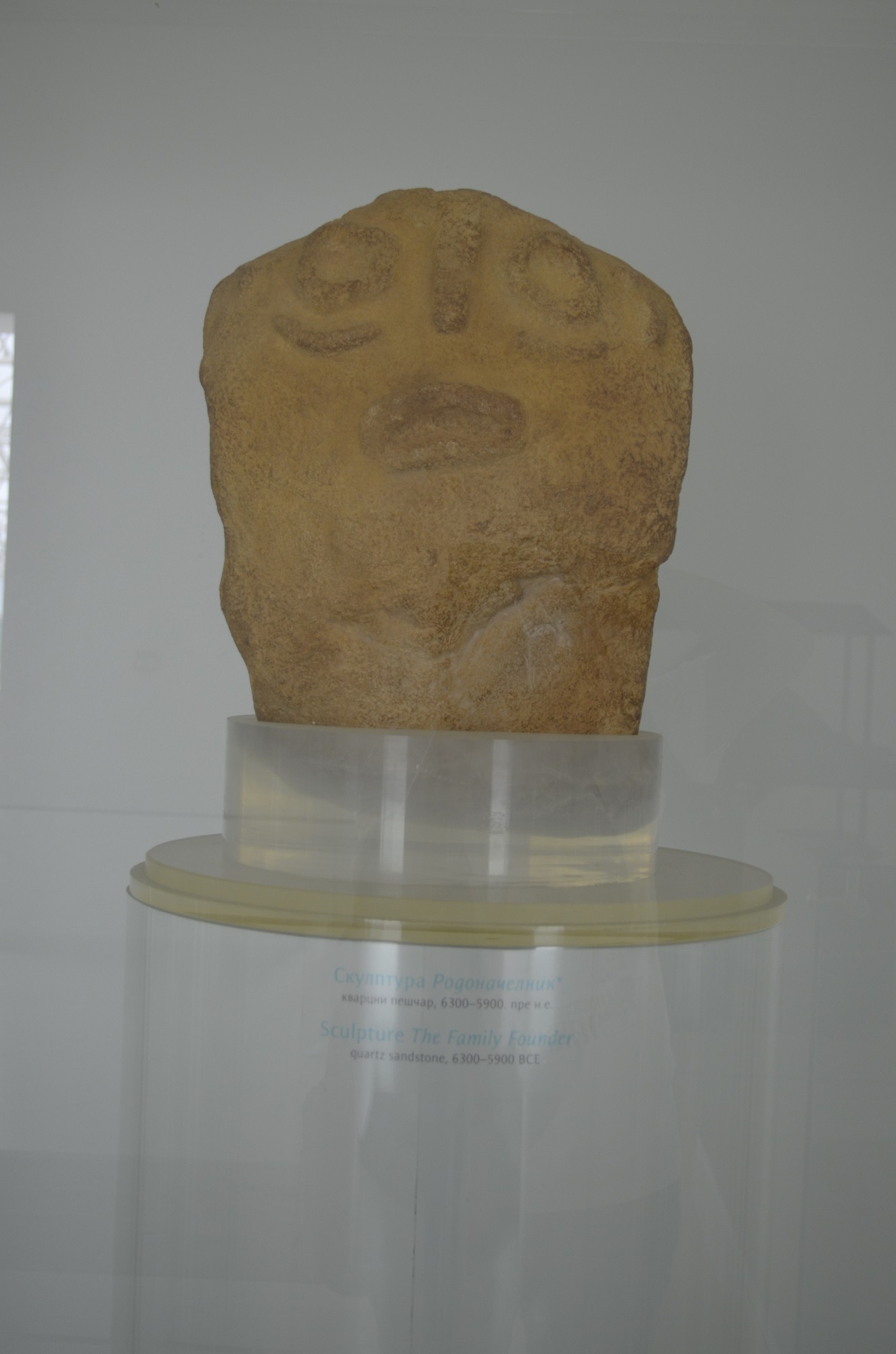
The explorations showed that the ore was extracted mostly in vertical shafts (pits), or in vertical ore lens channels with the diameter of 1.5–2 metres, so that two miners could work in them at the same time. The skill of prehistoric miners is supported by the depth of the shafts, with the deepest one being about 20 metres, while the layout of about 40 open shafts shows that copper ore in Rudna Glava was exploited intensively and lasted for a long time. This mine functioned from spring to autumn, when tools were stored in special rooms until the next seasons. The tools found in the five storage rooms were made of river pebbles originating from volcanic rocks and differing in their size and shape – massive rams with transverse grooves for clamping the ropes used for ore breaking and crushing; smaller tools, or wedges for crushing larger pieces of ore, and bone tools in the form of deer antlers used for collecting the broken and crushed ore. The ceramic bowls were also found – of large dimensions and massive walls, mostly pots and amphorae, which served for pouring water onto red-hot walls of the ore vein channels, in order to make ore brittle. In the storage rooms in Rudna Glava, parts of special bowls were found that had a cult character –altars with stylized representations of deer heads and recipients placed on four legs and decorated with geometric carvings. The ceramics and tools used by miners are made of local materials, together with the fact that there are no traces of other impacts, are a clear proof of the autochthonous knowledge, work and experience of Rudna Glava miners.

The found artefacts coming from the locality of the Mine – Open Pit, the ancient mine in Rudna Glava near Majdanpek: stone and bone tools, ceramic bowls and so-called ceramic altars, are part of the archaeological collection in the Museum of Mining and Metallurgy in Bor. The material on display represents the “tools and cult objects” of the miners who exploited this mine, today known as one of the oldest mines of malachite and azurite, copper minerals, which dates back to the end of the 6th and the beginning of the 5th millennium BC. 

Source: “History of Serbian Mining”, Slobodan Vujić, the Museum of Mining and Metallurgy in Bor

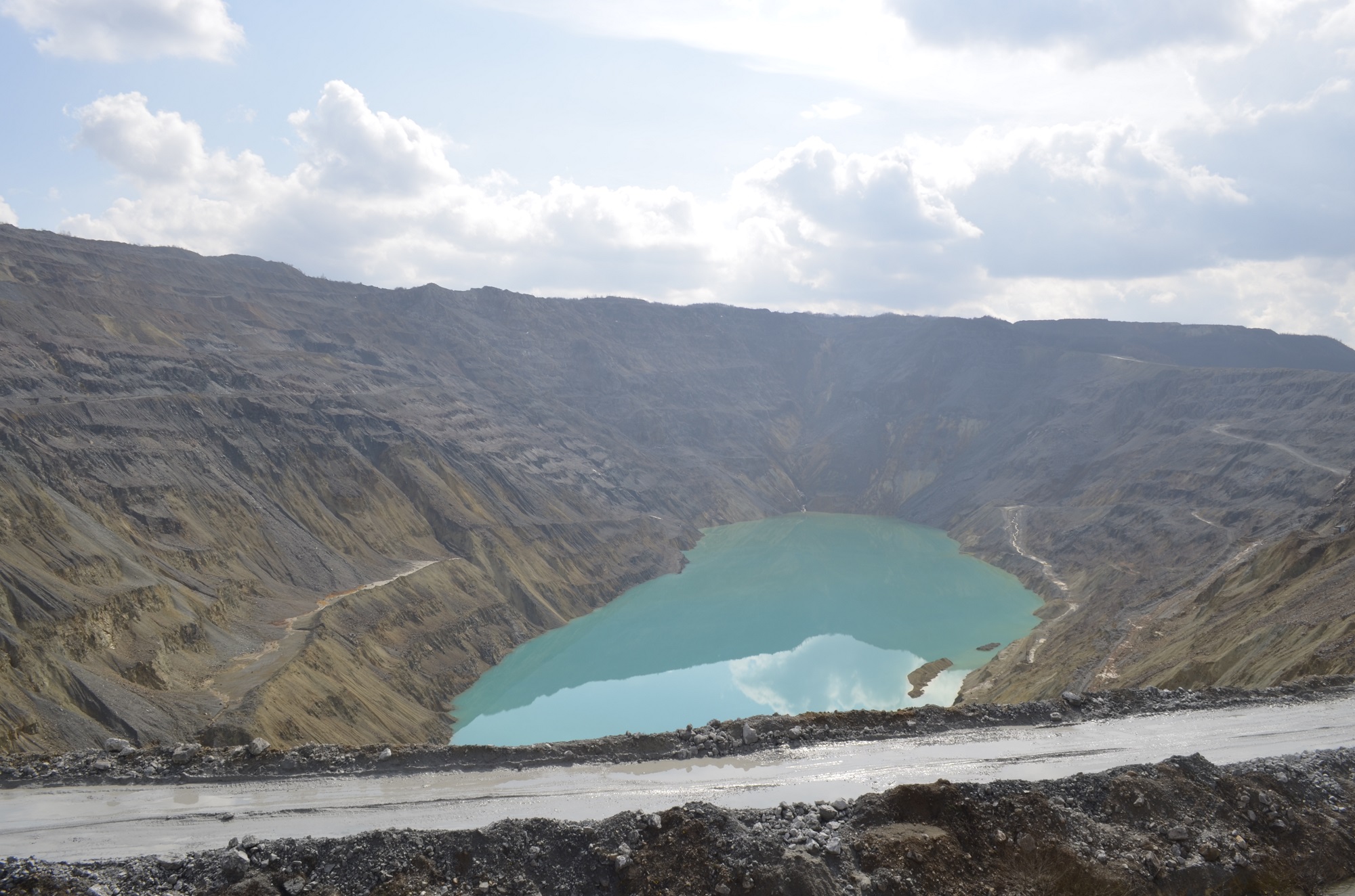
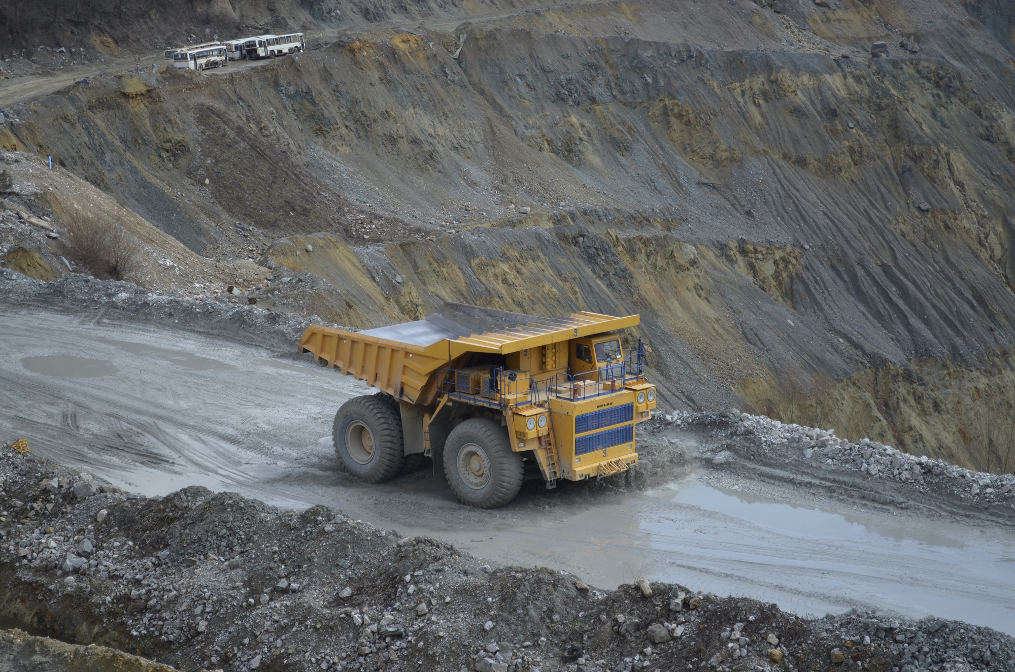
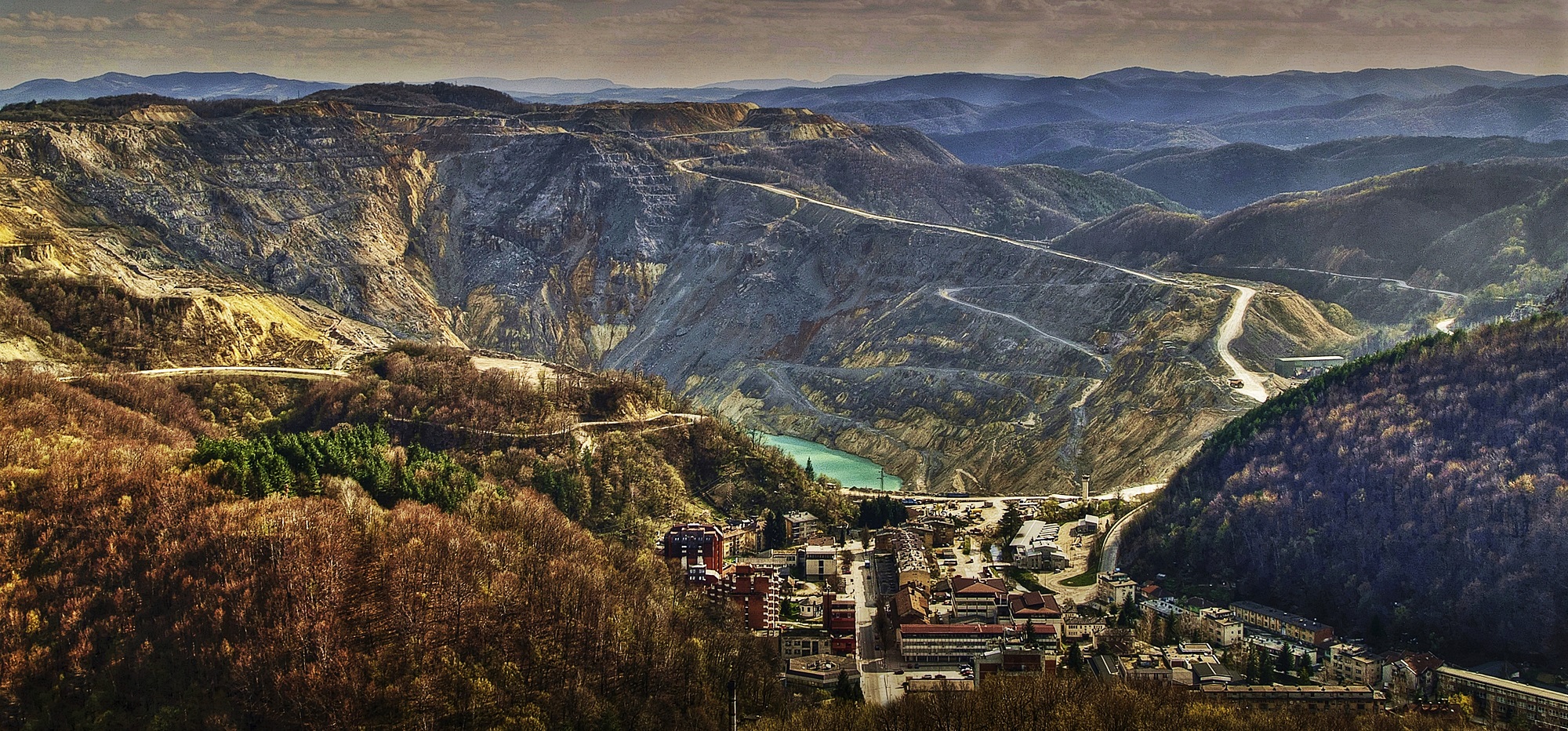
Majdanpek and mining through centuries

Mining in Majdanpek and its vicinity has been present for a very long time, more than seven thousand years. The name of this mining town has not been substantially changed since its first mention in the historical sources in the 16th century. Both the former Medani Pek and modern Majdanpek are the names containing the words copper, mine and the Pek. Although no systematic archaeological explorations have been conducted in Majdanpek, some accidental findings indicated the remains of the Eneolithic mining, as well as the presence of Ancient Romans, Byzantines, medieval Saxons, Turks and Austrians. Therefore, mining has been performed in the valley of Mali Pek for thousands of years.

In the distant past, in the period preceding the Trojan War, ancient Greeks are assumed to have exploited the gold-bearing rivers of today’s north-east Serbia, the richest of which was the Pek River.

The time when the Argonauts started searching for the Golden Fleece is also dated in the period of the 13th and 12th centuries BC. The presence of the Greeks in this territory, according to ethnologist Paun Es Durlić from Majdanpek, can also be proved by the name of the Pek River, as the second part of the compound name Majdanpek. According to Durlić, the hydronium Pek is of Greek origin and comes from pekos, meaning sheep fleece.

It is known that ancient Argonauts used to place sheep fleece into the riverbed for the purpose of gold washing. This ancient washing technique was maintained by the inhabitants in the Pek River Valley until quite recent times, while today it is mostly used for tourist purposes.

In written historical sources, Majdanpek as Medani Pek appears first in the 16th century, while the first written document with the name of the settlement dates back to 1560, when copper production was renewed in Medani Pek, as it was called by the Turks.

Earlier historiography related the beginning of Turkish exploitation to the year of 1574, when a certain spahi Behram was given a ziamet (land tenure) for having discovered and renewed the mine of Majdanpek with his own means. The historians’ assumption is that this is quite likely, and that spahi Behram started production in 1560 and was given the well-deserved reward in 1574.

A large number of researchers assigns Turkish origin to the name of Majdanpek. However, ethnologist Paun Durlić notes that the oeconym Medani Pek, documented both in Hungarian and in some later Western sources, is based on the word med, stating that it is definitely an old Serbian name for copper. He believes that the Turks actually inherited that name, which is also solid proof that this mine previously used to be in Serbian hands.

Medani Pek as an important crossroads at “17 days from Istanbul  is mentioned in the 17th century, which was recorded by Stojan Novakovič in his paper “Haji-Kalfa or Ćatib-Čelebija – the 17th century Turkish Geographer about the Balkan Peninsula”, published in the Almanac (Spomenik)  of the Serbian Royal Academy No. 18, Belgrade, from 1892.

This settlement with a similar name, which still contains the word med in its base, appears in the Western sources of the 18th century and since then it has gradually been suppressed by the competing Turkish form based on the Arabic word madan (mine, ore), widely accepted in Serbia in the form of majdan, with the same meaning.

Miners have been present here for many centuries, although in a modern way, not with sheep fleece, while the name of the mining town has been maintained with slight modifications to date.
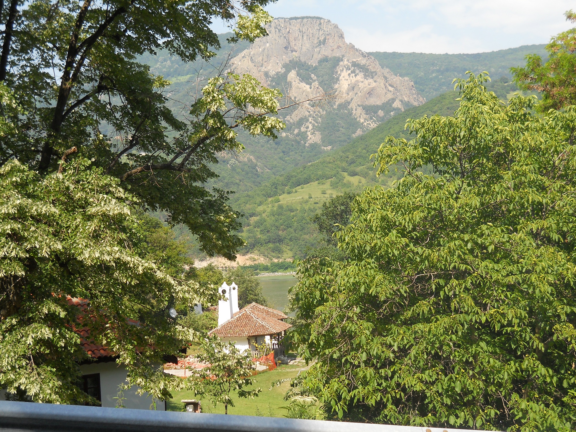
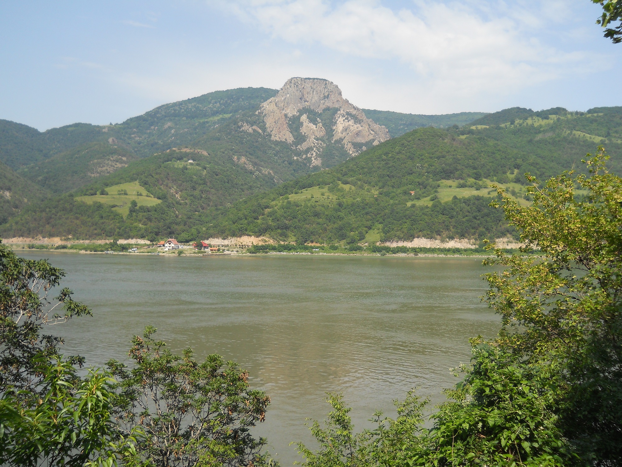
Treskavac

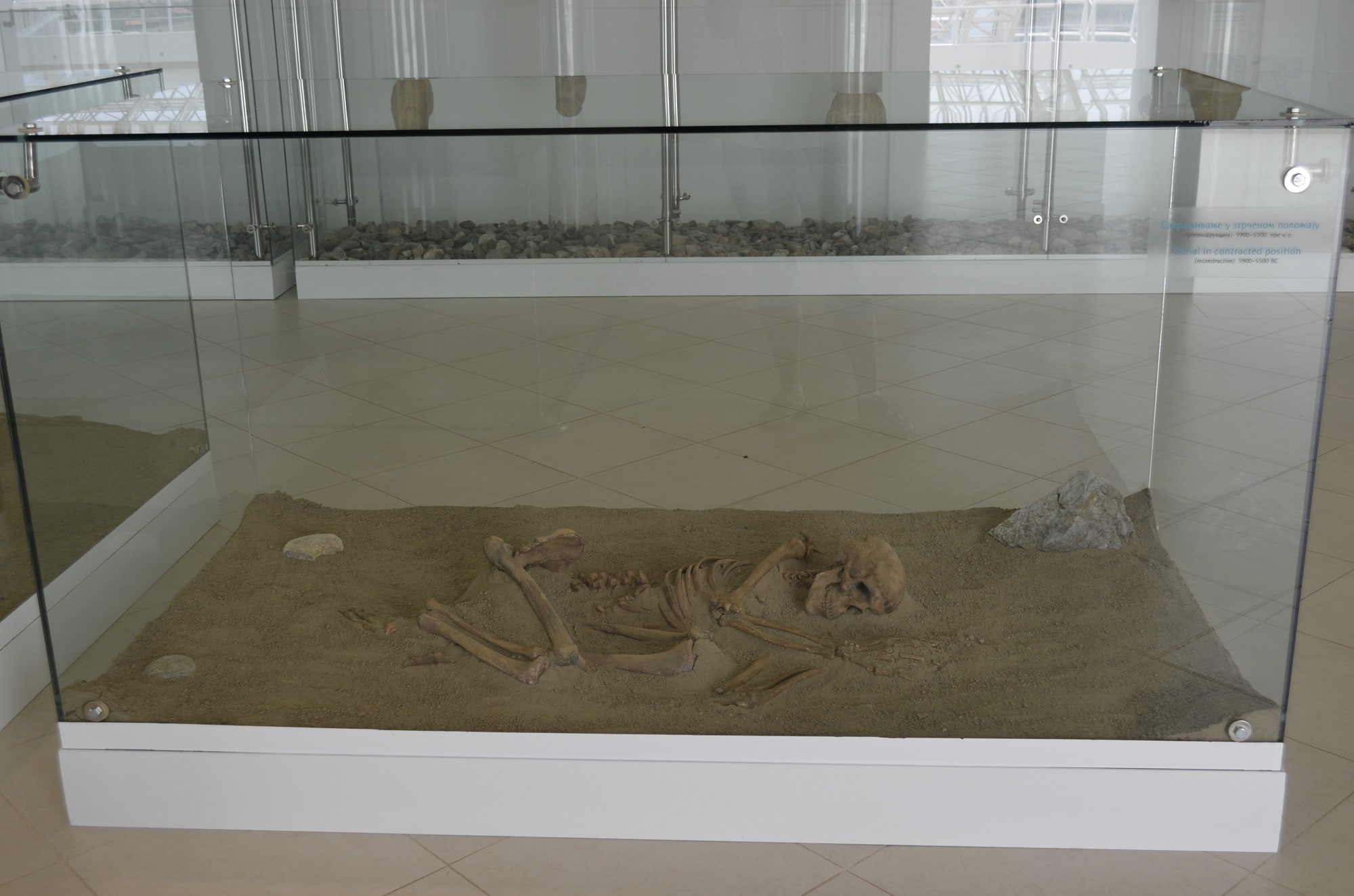
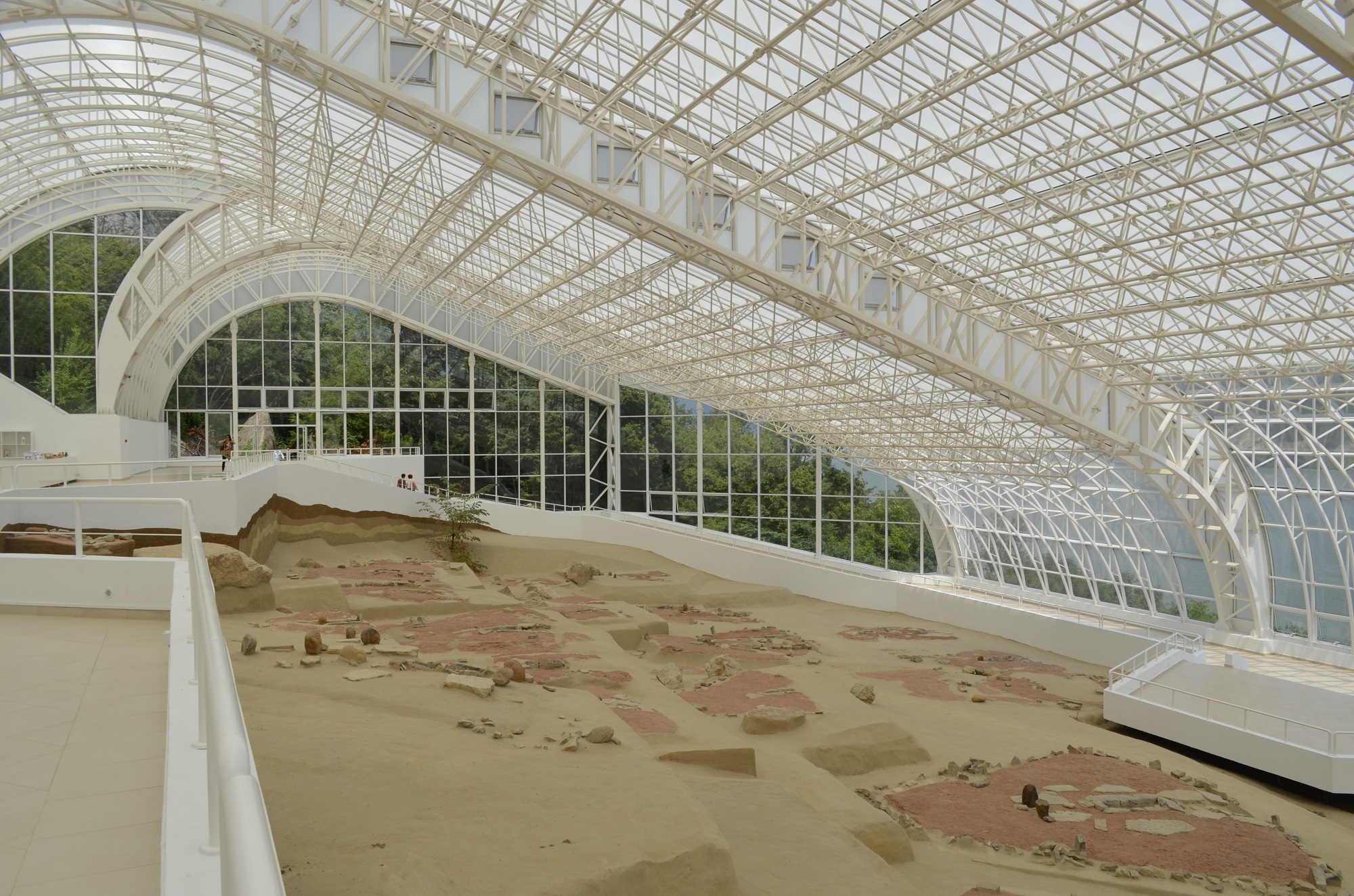
With the height of 755 m above sea level, Treskavac is one of the highest peaks in the Romanian Iron Gates natural park, opposite the first and only geopark inn Serbia, Djerdap UNESCO geopark.  The bare, almost vertical porphyry rock, as the last remnant of the long-extinct volcanic cone, is certainly one of the most impressive sights from both sides of this section of the Danube. Since it is opposite Lepenski Vir, many archaeologists and historians believe that the inhabitants of this prehistoric settlement had a special relationship towards Treskavac and that they intentionally build their houses in the shape of this rock trapezoid. It is particularly interesting that pieces of volcanic rocks from Treskavac, particularly those of silicified volcanic glass, were used in the cut stone industry in Lepenski Vir.

Today, we definitely do not know how Treskavac was looked at by our distant ancestors thousands of years ago, but it is evident that this peak, even after so much time, continues to intrigue the imagination of people living on both sides of the large river. There are frequently those who often believe in the supernatural features of Treskavac, while the crown proof for their beliefs is that almost all thunderbolts strike this very peak in a storm. That is how it got its name, which was accepted by Romanians in an adapted version of Trescovăţ, which would not be difficult to explain by the composition and position of the rock. However, some will always claim that “there is something in it”.

Furthermore, what has made Treskavac special throughout centuries is the double sunrise above this peak on the summer solstice, which can be seen in our time as well.

This astronomical phenomenon over the characteristic mountainous relief on the other side of the Danube is what nature provided to the former inhabitants of Lepenski Vir – a measuring instrument for orientation in time and a sort of calendar.

The double sunrise in Treskavac on the summer solstice was the starting point of that calendar and ancient inhabitants of Lepenski Vir watched how the sunrise point moved right on that particular day, which announced shorter days. It lasts until winter solstice on 21st December, when the sun rises behind the peak of Kukujovo and the process reverses.

Researchers and archaeo-astronomers believe that the inhabitants of Lepenski Vir noticed the regularity in the movement of the sunrise on the eastern horizon with the change of seasons, as well as that, according to the predicted changes, this community was able to prepare the stocks of food, warm clothes and kindling in a timely manner, and to find a safe shelter for the winter period. In his works, the founder of archaeometeorology, Professor Clive Bonsall, observes that Lepenski Vir is the only of several settlements of the same civilization in Djerdap Gorge that survived the cooling period 8,200 years ago, when Europe was stricken by strong rain and floods, while the inhabitants of the neighbouring settlements left their dwellings. Academician Dragoslav Srejović, who discovered Lepenski Vir, noticed the direction of most houses in this settlement towards Treskavac. He explained it by exceptional significance assigned to Treskavac by the inhabitants of Lepenski Vir.

The following

Geological heritage sites

Contact

Public Enterprise
Djerdap National Park
st. Kralja Petra I No. 14a
19220 Donji Milanovac, Serbia
E-mail: office@npdjerdap.rs
Headquarter: +381 (0)30 215 0070

Copyright © 2020 Djerdap Geopark. All rights reserved.
Shopping Basket

The attractiveness of Lepenski Vir has been recognized by, among many, companies, organizations and artists, to whom this locality served as inspiration and trade mark. Many prominent painters, among whom are Mario Maskareli, Milic od Macve, Vojislav Zizic, Dragan Mojovic, Dragan Stojkov, Bratislav Stojanovic, Marica Radojcic, Mirjana Lehner and many others, transformed the fascinating monumental sculptures into first class works of art.

Along with them were famous writers who have put the impression of Lepenski Vir to paper: Milorad Pavic, Miodrag Pavlovic with the works Pevanja na Viru (Singing in the Rain), Nova pevanja na Viru (New singing in the rain), the essay Lepenski Vir: Sculpture and myth (Skulptura i mit), as well as Dusan Matic, Zoran Milic, Ivan Gadjanski. For the children’s book of Jovan Janicijevic, Vodena vila iz Lepenskog Vira (Water Fairy from Lepenski Vir) and Klinče iz Vinče (Child from Vinca), the two localities served as inspiration, both special and fantastic, each in its own way.

The Motive of Lepenski Vir appears on stamps in 2003. One of the most famous monumental stone sculptures found its place on a home made biscuit, which you can get with coffee in many cafes in Serbia. In 1995, the same sculpture served as a trademark of the activity of the Ministry of Culture on the occasion of announcing The Year of Culture, “It is more beautiful with culture“. The sculpture had sunglasses and a smile, and it became a symbol of the cultural rebellion against social values and the position it had in society.

The text downloaded from http://www.narodnimuzej.rs/zanimljivosti/lepenski-vir-in-popular-culture/?lang=en

Широм света познати деликатес кавијар је данас и синоним за луксузан залогај, статусни симбол и храна богатих. Некада је „рибљи ајвар“ (како су га звали ђердапски аласи) био храна сиромашних, радника, рибара и њихове деце, као намаз на црном хлебу.

Јесетарске рибе, од чије се икре израђивао кавијар, ловљене су до изградње ђердапске бране, у Госпођином виру, на Гребену, Јуцу, у Казану и код Сипа. Ђердапски кавијар био је веома цењен на европским трпезама. Организованији начин прераде и промета кавијара започет је 1920. појавом руских емиграната на простору Ђердапа.

У другој половини 20. века Рибарско газдинство „Ђердап“ из Кладова било је једини произвођач кавијара у Југославији који се извозио и у САД.

Споменик природе Тунелска пећина Прераст у кањону Замне („Службени гласник РС“, број 81 од 5. јуна 2020. године) представља геоморфолошки феномен на источној страни Дели Јована, на реци Замни и сврстава се у I категорију заштићеног подручја међународног, националног односно изузетног значаја. Налази се на подручју општине Неготин, укупне површине 39 ha.

Споменик природе Тунелска пећина Прераст у кањону Замне је тунелска речна пећина са сталним речним током. Настала је подземним флувио-крашким усецањем Замне, што је у одмаклој фази еволуције омогућило настанак процеса обрушавања, чиме су у пећини отворена два отвора у таваници (вигледи). Пећина представља јединствен и једноставан пећински канал дужине 155 m, у чијем поду је речно корито Замне. Због два велика отвора у таваници ова тунелска пећина је целом дужином под дневном светлошћу. Захваљујући постојању ових отвора, на улазу и на излазу, пећински тунел има изглед огромне прерасти. Отвори у таваници су удаљени један од другог око 70 m.

Клисура Замне је рефугијално станиште великог броја животињских и биљних врста са очуваном вегетацијом, по чему је изузетно значајно подручје биолошког диверзитета који заслужује заштиту.

Споменик природе Тунелска пећина Прераст у кањону Замне поверен је на управљање Туристичкој организацији општине Неготин.

Cпоменик природе Бигрена акумулација Бели изворац (Службени лист општине Мајданпек број 06-52/4 од 27.12.2006. године), значајан због своје изузетности и очуваности као геоморфолошки објекат површинског крашког рељефа, сврстан је у III категорију као значајно природно добро. Налази се у сливу реке Шашке, на територији општине Мајданпек, укупне површине 6 ha.

У долини Белог изворца постоје две акумулације бигра различите старости, таложене једна преко друге. Ово природно добро има велики број облика, појава и процеса, који је водоток Белог изворца формирао у наталоженим наслагама бигра, низводно од изворишта поменутог водотока. На релативно малом простору (око 300 m) налази се велики водопад, висине 16 m.

Испод водопада, понирањем воде кроз бигар, образован је пећински канал дуг 13 m и широк 4 m, отворен са једне и друге стране. Преталожавањем бигра у пећини су образовани саливи и сталактити од чисте беле сиге. Низводно од водопада, у кориту потока, постоје бројне преграде од бигра, иза којих су образоване бигрене акумулације језерца пречника до 10 m и дубине 2-3 m. Преко преграда поток се слива у виду слапова и мањих водопада, међу којима су два висока 5 m.

Споменик природе Бигрена акумулација Бели изворац поверен је на управљање Туристичкој организацији општине Mајданпек.

Споменик природе Бигрена акумулација код манастира Тумане (Службени лист општине Голубац број 633-2/2009) представља геоморфолошко-хидролошки објекат стављен под заштиту ради очувања као посебног природног феномена и сврстава се у III категорију као значајно природно добро. Налази се на територији општине Голубац, укупне површине 8550 m2.

Споменик природе Бигрена акумулација код манастира Тумане се налази у средишњем делу тока Каменице, 1,1 km узводно од ушћа у Туманску реку, на 250 m н. в. и у подножју десне долинске странe. На овом подручју, малом простору у дужини од око 200 m, јавља се већи број морфолошких облика и то слап висине 14 м, низ мањих слапова, прелива и бигрених када.

Посебност Споменика природе Бигрена акумулација код манастира Тумане чине: испосница у самом бигру, јединствена у Србији, чесма на којој се приносе дарови душама умрлих, стара букова и храстова шума.

Бигрена акумулација код манастира Тумане је под старатељством Туристичке организације општине Голубац.

Споменика природе Бледерија (Уредба Владе Републике Србије 05 број 110-8258/2019-2 од 20. децембра 2019. године, „Службени гласник РС“, број 93 од 26. децембра 2019. године) проглашено је заштићеним подручјем II категорије – регионалног, односно великог значаја. Споменик природе „Бледерија” налази се на територији општине Кладово, укупне површине 398 ha.

Подручје око речице Бледерије на југозападном ободу регије дунавског Кључа, југозападно од Кладова, атар села Река, заштићено је да би се очувало богатство и разноврсност облика геодиверзитета: извориште Бледерије разбијеног типа са четири места истицања врела, два акумулативна водопада, од којих је низводнији висине око 7 m и због своје лепоте и богатства воде представља објекат хидролошког наслеђа Србије; затим велике акумулације бигра у доњем току, врелске пећине Соколовице, са истоименим повременим врелом гравитационог типа и периодским током који је низводно од локалитета Град до састава са токовима Суваје и Бледерије усекао живописну кречњачку клисурицу, са неколико изразитих сужења и слапова.

На подручју Споменика природе Бледерија налази се фрагментно очувана шумска вегетација у комплементарности са биљним и животињским светом.

Споменик природе Бледерија поверен је на управљање Туристичкој организацији општине Кладово.

Споменик природе Прераст Шупља стена (Уредба Владе Републике Србије 05 број 110-777/2019-1 од 23. маја 2019. године, „Службени гласник РС“, број 36 од 24. маја 2019. године) заштићен је ради очувања геоморфолошких, хидрографских и ботаничких вредности масивног природног каменог моста – прераста, као природног феномена флувиокраса окруженог широким појасом шуме, висине од 9,5 м изнад корита реке Прераст. Сврстава се у I категорију заштићеног подручја међународног и националног, односно изузетног значаја. Споменик природе се налази на територији општине Мајданпек, укупне површине је око 8 ha.

У просторном оквиру заштићеног природног добра издваја се више различитих геоморфолошких и хидролошких вредности. Доминантно место припада каменом мосту, прерасти, феномену флувиокраса источне Србије. У кречњакој зони, заступљен је типичан крашки рељеф са пуно вртача, стрмих кршевитих литица и мањих спелеолошких објеката. У кориту речице Прераст на улазу у Шупљу стену са леве стране налази се мањи понор, чија се вода појављује на излазу из прераста. Поред наведеног, постоји и мањи извор који избија из кречњачке пукотине. Прераст Шупља стена је посебно значајан због своје изузетности и очуваности као геоморфолошки објекат. Прераст је усечена у виду грандиозног природног каменог моста у кречњацима. Отвор прерасти при дну, у висини речног корита износи 9,5 m. Висина отвора лука је 29,5 – 34 m, а висина до горње ивице лука износи 44,8 m.

Споменик природе Прераст Шупља стена поверен је на управљање Туристичкој организацији општине Мајданпек.

Качамак или мамаљига традиционално јело у Ђердапу спрема се од топле воде, кукурузног брашна, масти и соли. Из котлића се излива у тепсије и качамак добија округао изглед. Служи се са млеком, сиром, јогуртом, испрженим црним луком, сушеном белом рибом, сланином и сече танким концем.

Припремао се раније и као посластица када се ређао ред качамака и ред џема, након чега се посипао прженим презлама. Гушће справљен и запечен под црепуљом користио се као замена за хлеб.

Боравећи за време II светског рата изнад села Бољетин, припадници енглеске војне мисије послужени су влашким качамаком, а шеф мисије Џаспар Рутам записао је да су за јело добили „округлу жуту торту која није била слатка“.

Рано енеолитски рудник Рудна Глава код Мајданпека (5000. година пне.) пример је најстарије познате технологије бакра. Истражен је 1968-1989. године у оквиру пројекта Старо рударство и металургија средишњег Балкана.

Најстарија рударска технологија, упозната у Рудној Глави, разрешила је недоумице око порекла примарног рударског и минералошког знања. Велику умешност старих рудара на Рудној Глави потврђују испражњена окна дубине до око 20 метара. Велика серија камених батова, крупних речних облутака од вулканских стена, сведочи о специјализацији примарног каменог алата за различите производне функције.

За уситњавање комада руде употребљавани су различити дрвени клинови, док су алати од јеленског рога служили првенствено за прикупљање већ иситњене руде. Када су исцрпили карбонатне минерале бакра, малахит и азурит, доступне технологији којом су располагали, винчански рудари раног енеолита, напустили су овај рудник.

Ово скромно лежиште гвоздене и бакарне руде – магнетита и халкопирита – поново су користили, са новом технологијом, римски рудари – робови у 3. веку после Христа.

(Текст др Борислава Јовановића и мр Александра Петровића преузет са проспекта у издању Завода за уџбенике и наставна средства РС, Београд, 1998)

Активних вулкана данас нема у Србији и вероватноћа да ће их у будућности бити мери се хиљадама година. Иако их данас нема, подручје Србије је у геолошкој историји било веома активно, а трагови некадашњих вулкана и данас постоје.

Различитих вулканских активности било је од најстаријег геолошког времена, али је детаљнија реконструкција могућа само за последњих 300 милиона година. То обухвата вулкане каснопалеозојске (пре 300 милиона година), тријаске (пре 220 милиона година), јурске (пре 150 милиона година), горњокредне (пре 90 милиона година) и терцијарне (пре 65 милиона година) старости.

На подручју источне Србије крајем палеозоика одвијао се субаерски вулканизам, а ретки продукти ових ерупција у Србији као мали остаци излива лаве и вулканокластита јављају се код Бољетина, али су ове стене данас углавном под водом. Најупечатљивији су риолитски остаци Трескавца на румунској обали Дунава, преко пута Лепенског Вира, а посебна занимљивост је да су комади ових вулканских стена, посебно они од силификованог вулканског стакла, коришћени у Лепенском Виру у индустрији окресаног камена.

У тимочком подручју данас су присутни бројни остаци горњокредних стратовулкана: Црни врх, Тилва Њагра, околина села Јасиково и Влаоле, околина Брестовачке Бање, Чока Марин и друга места. На пределу где се некад уздизао борски стратовулкан Тилва Рош данас је површински коп пречника од неколико километара.

Атрактивност Лепенског Вира препознале су, међу многима, и компаније, организације и уметници, којима је овај локалитет послужио као инспирација или заштитни знак.

Многи реномирани сликари, од којих треба поменути: Марија Маскарелија, Милића од Мачве, Војислава Жижића, Драгана Мојовића, Драгана Стојкова, Братислава Стојановића, Марицу Радојчић, Мирјану Лехнер и многе друге, преточили су фасцинантност монументалних скулптура у врхунска уметничка дела. Раме уз раме с њима, стајали су познати књижевници, који су у речи преточили импресију Лепенског Вира: Милорад Павић, Миодраг Павловић са делима Певања на Виру, Нова певања на Виру, есејем Лепенски Вир: скулптура и мит, затим Душан Матић, Зоран Милић, Иван Гађански. За дечију књижицу Јована Јанићијевића, Водена вила из Лепенског Вира и клинче из Винче, два локалитета су послужила као инспирација, оба посебна и фантастична, сваки на свој начин.

Мотив Лепенског Вира појављује се на поштанским маркама 2003. године. Једна од најпознатијих монументалних камених скулптура налази се на популарном домаћем кексу, који можете добити уз кафу у многим кафићима у Србији. Године 1995, иста скулптура послужила је као заштитни знак акције Министарства културе поводом проглашења Године културе, „Лепше је са културом“. Скулптури су додали наочаре за сунце и осмех, а она је постала симбол бунта културе против социјалних вредности и положаја који је заузимала у друштву.

Tекст преузет са http://www.narodnimuzej.rs/zanimljivosti/lepenski-vir-u-popularnoj-kulturi/

The early Chalcolithic mine Rudna Glava near Majdanpek (5000 BC) is an example of the oldest known copper mining technologies. It was under an archaeological investigation from 1968 to 1989, within the project “Old Mining and Metallurgy of the Central Balkans”.

The oldest mining technology found in Rudna Glava has resolved doubts about the origin of primal mining/mineralogical knowledge. Up to 20 m deep mine shafts confirm great technical skills of the early miners at Rudna Glava. Numerous massive pebbles of volcanic origin, obtained from the local river deposits and used as heavy mining hammers, indicate the development of early stone tools for different production functions.

Various wooden tools were used for crushing the ore, while deer antler tools were used primarily to collect the grinded material. After the exhaustion of copper-carbonate minerals (malachite and azurite), which were the only minerals compatible with the technology at the time, the early Chalcolithic miners of the Vinča culture abandoned the mine. This minor deposit of iron and copper, with magnetite and chalcopyrite ore, was exploited again in the 3rd century AD, using new technologies and workforce of Roman slaves.

(Dr. B. Jovanović, MA A. Petrović, Institute for Textbooks and Teaching Aids of RS, Belgrade, 1998)

The Natural Monument “Natural Arches in Vratna Gorge” (“Official Gazette of RS”, No. 99/2014) is a geomorphological phenomenon, declared a protected area of 1st category, of national and exceptional importance. It is located in the municipality of Negotin, with a total area of 144.75 ha.

It represents a unique form of underground and surface karst morphology created by a local sink of the river flow and a partial collapse of the through cave’s ceiling. Along 3 km of the river flow, three natural arches have been formed over the Vratna River: Suva Prerast, Velika Prerast and Mala Prerast.

The area of the Natural Monument “Natural Arches in Vratna Gorge” is protected in order to preserve specific forest vegetation, i.e. a complex community characterized by the presence of endemic and relic (tertiary) species, as well as the exceptional diversity of fauna.

The management over this natural monument is entrusted to the State Enterprise for Forest Management “Srbijašume”, Belgrade.

The Natural Monument “Prerast Tunel Cave in Zamna Gorge” (“Official Gazette of RS”, No. 81/2020) is a geomorphological phenomenon on the east side of Deli Jovan Mountain, on the Zamna River and is classified as a protected area of 1st category of international, national and exceptional significance. It is located in the municipality of Negotin, with a total area of 39.50 ha.

The Natural Monument “Prerast Tunel Cave in Zamna Gorge” is a tunnel cave with a perennial stream. It has been formed by the subterranean fluvio-karstic incision of the Zamna River, which enabled the collapse processes in an advanced phase of evolution, resulting in the formation of two openings in the cave ceiling (skylights).

The cave is represented with a single, simple and 155 m long cave passage, which host the riverbed of Zamna River. Due to the two large openings in the ceiling, which are around 70 m apart, this tunnel cave is under daylight along its entire length. Because of the existence of these openings, at the entrance and at the exit of the cave passage, the cave resembles a huge natural arch. The Zamna River Gorge is a refugium of a large number of animal and plant species, with well-preserved vegetation, making it an outstandingly important area of biodiversity, deserving to be protected.

The management over the Natural Monument “Prerast Tunel Cave in Zamna Gorge” is entrusted to the Tourist Organisation of the Municipality of Negotin.

The Natural Monument “Beli Izvorac Tufa Accumulation” (“Official Gazette of the Municipality of Majdanpek”, No. 29/2006) is a unique geomorphological and hydrological phenomenon of the surface karst relief.

A part of the Beli Izvorac Creek, from its source to the elevation of 278 m a.s.l, with a length of 300 m and the adjoining tufa accumulations, is protected as a natural monument and declared a significant natural resource, i.e. a natural resource of 3rd category. It is located in the municipality of Majdanpek, with a total area of 6.02 ha.

It is protected in order to preserve a large number of fluvio-karstic landforms, phenomena and processes (karst spring; large, 16 m high waterfall; several small waterfalls and cascades; numerous tufa rimstones with rimstone pools; etc) which have been formed in the tufa accumulations by the Beli Izvorac Creek, in a relatively small area downstream from the spring.

The management over the Natural Monument “Beli Izvorac Tufa Accumulation” is entrusted to the Tourist Organisation of the Municipality of Majdanpek.

The Natural Monument “Tufa Accumulation near Tumane Monastery” (“Official Gazette of the Municipality of Golubac”, No. 1/2009) is a geomorphological and hydrological object of the surface karst relief near the Tumane Monastery.

It consists of a tufa accumulation with a number of geomorphological forms and is declared a significant natural resource of 3rd category. Located in the municipality of Golubac, with a total area of 8550 m2, it occupies the central part of the Kamenica Creek, at 250 m a.s.l. or 1.1 km upstream from the confluence of the Kamenica Creek and Tumanska Reka River.

This natural phenomenon, having a terraced, fan-shaped form and height of approximately 14 m, is a palaeogeographic indicator valuable for the reconstruction of climate, vegetation and geomorphological processes in the past. 14 m high waterfall and a series of small cascades, barrages and rimstone pools occupy a small area, at a length of around 200 m. Special features of this natural monument are: a hermitage carved out of tufa (which is unique in Serbia), a fountain where gifts are offered for the repose of souls, old beech and oak forests.

The management over the Natural Monument “Tufa Accumulation near Tumane Monastery” is entrusted to the Tourist Organisation of Golubac.

The Natural Monument “Šuplja Stena Natural Arch” (“Official Gazette of RS”, No. 36/2019) is a geomorphological and hydrological phenomenon on the Valja Prerast River, which is classified as a protected area of 1st category of international, national and exceptional significance. It is located in the municipality of Majdanpek, with a total area of 8.27 ha.

The Natural Monument “Šuplja Stena Natural Arch” is protected in order to preserve the geomorphological, hydrographic and botanical values ​​of the massive natural arch – a fluvio-karstic phenomenon surrounded by a wide forest belt.

A span of the natural arch is 9.5 m, with a height of its lower edge of 29.5-34 m and a height of its upper edge of 44.8 m. A typical karst relief with dolines, limestone cliffs, short caves, a swallet and a karst spring is developed within the protected area.

The management over the Natural Monument “Šuplja Stena Natural Arch” is entrusted to the Tourist Organisation of the Municipality of Majdanpek.

The Natural Monument “Blederija” (“Official Gazette of RS”, No. 93/2019) encompasses the Blederija River on the southwestern rim of the Ključ region and is declared a protected area of 2nd category of regional and high significance. It is located in the municipality of Kladovo, with a total area of ​​398.87 ha.

The Natural Monument “Blederija” is protected in order to preserve the richness and geodiversity of the area: complex source of the Blederija River, with four outflows; two tufa waterfalls, of which the lower one has a height of approximately 7 m and is listed as an object of hydrological heritage of Serbia, due to its beauty and abundance of water; large tufa accumulation in the lower course; spring caves of Sokolovica, with the eponymous intermittent gravity spring and the periodic stream which incised a picturesque limestone gorge downstream of the Grad locality, all the way to the confluence with the Suvaja and Blederija Rivers, with several distinct narrowings and cascades. This area hosts fragmentary preserved forest vegetation, in complementarity with flora and fauna.

The management over the Natural Monument “Blederija” is entrusted to the Tourist Organisation of the Municipality of Kladovo.

Cornmeal porridge (”mamaljiga“ in Wallachian) is a traditional dish in Djerdap area, made of hot water, corn flour, fat and salt. While still hot, it is poured from the cauldron into pans, thus getting a round shape. It can be served with milk, cheese, yogurt, fried onions, dried white fish or bacon.

Instead of a knife, a piece of sewing thread is commonly used to cut cornmeal porridge into slices. It also used to be prepared as a dessert, arranging alternating rows of porridge and jam, with fried breadcrumbs sprinkled on the top. Thickly prepared and baked in a traditional clay oven, it can be used as a substitute for bread.

During their stay near Boljetin village, members of the WWII British military mission were served with cornmeal porridge; the head of the mission, Jasper Rootham, wrote that they were given “a round yellow cake that was not sweet”.

Today, there are no active volcanoes in Serbia and it is not likely that we will see one any time soon. Nonetheless, the territory of Serbia was very active in geological history and traces of former volcanoes still exist. Various volcanic activities go back to a distant geological history, but best evidenced events date back to last 300 million years. These include Upper Paleozoic (300 million years old), Triassic (220 million years old), Jurassic (150 million years old), Upper Cretaceous (90 million years old) and Paleogene volcanoes (65 million years old).

At the end of the Paleozoic, a subaerial volcanism took place in Eastern Serbia. Products of these eruptions, represented with minor lava flows and volcaniclastics near Boljetin village, are scarce and for the most part submerged. The most impressive is the rhyolite lava neck of Mount Trescovăţ on the left Danube’s bank in Romania, just opposite to the Lepenski Vir archaeological site on the Serbian bank. Some of these volcanic rocks, especially silicified volcanic glass, were used for stone carving in the Lepenski Vir culture.

Numerous remnants of Upper Cretaceous stratovolcanoes are still present in the Timok area: Crni Vrh Mountain, Tilva Njagra Mountain, Čoka Marin Hill, as well as in the vicinity Brestovačka Banja Spa and Jasikovo and Vlaole villages. On the location of what used to be Tilva Roš Stratovolcano, today stands an open-pit copper mine, with a diameter of several kilometers.

Caviar is a world-famous delicacy, synonymous with a status symbol, luxury, wealth. However, caviar (or “fish ajvar“, as Djerdap fisherman used to called it) spread on whole-wheat bread was a food of the poor, workers, fishermen and their families.

It was made from roe, harvested from several species of sturgeon; up to the construction of the Djerdap Dam, these fish were caught in several sectors of the Djerdap Gorge: Gospođin Vir, Greben, Juc, Kazan and Sip. Caviar from Djerdap was highly prized across Europe. Well-organized caviar production and trade was established in 1920, with the arrival of Russian emigrants.

By the second half of the 20th century, Đerdap Fish Farm from Kladovo was the only caviar producer in former Yugoslavia and this caviar was exported as far as to the USA.

Споменик природе Прерасти у кањону Вратне („Службени гласник РС“, број 99 од 11. септембра 2014. године) представља геоморфолошки феномен, проглашен заштићеним подручјем I категорије од националног односно изузетног значаја. Налази се на подручју општине Неготин, укупне је површине 144 ha.

Представља јединствен облик подземне и површинске крашке морфологије настао локалним понирањем речног тока и урушавањем делова таванице речне пећине. Над реком Вратном, на дужини од 3 km формирана су три природна камена моста, односно прерасти: Сува прераст, Велика прераст и Мала прераст.

Подручје Споменика природе Прерасти у кањону Вратне стављено је под заштиту ради очувања специфичне шумске вегетације односно мешовитог сложеног састава који карактерише присуство терцијарних и ендемореликтних врста, као и изузетне разноврсности фауне.

Споменик природе Прерасти у кањону Вратне поверен је на управљање Јавном предузећу „Србијашуме” Београд.